

SERVICES
Accelerate your projects with VoxelTwin and digitize your physical world
The Ways We Help You
VoxelTwin is the answer to a timely and highly accurate digitization process of the physical world around us. What we do changes the way you go about your business; providing the most up-to-date information needed and for uses that you define.
With nearly two decades of experience in reality capture, and leading the industry in pioneering processes and technology implementation years ahead of our competition, we remain committed to staying ahead while providing an unprecedented level of quality service.
As-Built BIM For AEC/O
With decades of experience supporting AEC/O professionals, we offer industry-leading As-Built BIM services that capture the true state of your building with accuracy and efficiency.
Our expert team combines deep industry knowledge with the latest in reality capture technology to deliver high-value models that streamline design, construction, and operations. From complex renovations to large-scale infrastructure projects, we provide the clarity and precision necessary for confident decision-making.
_edited.jpg)


We extensively utilize NavVis LX LiDAR systems to capture high-resolution indoor environments at sub 1/8" accuracy at a speed of business, seamlessly integrating point cloud data into our BIM and AI driven solutions for fast and accurate delivery or BIM ready As-Builds.
Our workflows ensure geometrical fidelity, metadata enrichment, and alignment with industry-standard LOD 200 requirements, enabling downstream uses for an efficient Design Development, 3D coordination, quantity take-offs, and facility lifecycle management.
Data Hosting & Management
The technology we use for data hosting is built on robust, scalable cloud infrastructure designed to handle complex, high-resolution spatial datasets with speed and reliability. It enables seamless integration with Common Data Environments (CDEs), allowing captured data and BIM models to be securely accessed within your existing digital workflows. With full interactivity across platforms and advanced Pixel Streaming, users can explore rich 3D environments directly from a browser - no downloads or high-end hardware required.


Built-in data privacy controls ensure secure collaboration, while fast processing times and global accessibility allow project teams to stay connected and productive across time zones.
Importantly, we don’t do this alone. We rely on strategic partnerships with providers of world - class cloud and visualization technologies - organizations that set the benchmark for performance, security, and interoperability. These partnerships ensure that every VoxelTwin solution is backed by the reliability, scalability, and innovation of industry leaders.
Construction Progress Monitoring
VoxelTwin is redefining how construction progress is monitored by combining advanced reality capture technology with intelligent data workflows tailored to the needs of project teams. Using a fusion of NavVis mobile LiDAR, Staryos drone photogrammetry, and AI-driven comparison tools, we provide accurate, up-to-date visualizations of actual site conditions against planned models and schedules. Progress is no longer just a percentage—it becomes measurable, verifiable, and visible in 3D.
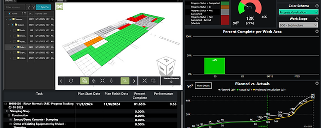


This capability is powered not just by our in-house expertise, but through close collaboration with partners who deliver best-in-class hardware, software, and analytics platforms. By integrating our capture workflows with tools like BEXEL Manager and leveraging cloud-based coordination environments,
VoxelTwin ensures that stakeholders can access progress data in real time—anywhere in the world, across any device. The result is greater transparency, reduced rework, and more informed decision-making from start to finish.
Lidar Scanning & UAV Capturing
LIDAR scanning and UAV photogrammetry are transforming how design and construction teams understand and interact with the built environment.These technologies provide fast, highly accurate spatial data that captures every detail of a site—from tight interior spaces to large-scale exteriors—with millimeter-level precision.
For architects and engineers, this means designing with real-world conditions from day one, reducing assumptions and clashes. For contractors, it enables precise quantity verification, layout validation, and progress tracking with confidence.


By combining high-density LIDAR point clouds with aerial photogrammetry from UAVs, project teams gain a complete, multidimensional view of their environment—captured safely, rapidly, and without disruption to site activities.
These digital records become the foundation for better coordination, fewer delays, and more predictable outcomes across every stage of a project’s lifecycle.
Digital Twin Foundation
At the core of our approach is data accuracy and interactivity, supported by gaming-engine deployment, data management and model optimization workflows. From the earliest conceptual layouts to detailed 4D/5D construction sequencing, our methodology ensures that every asset in the digital twin is grounded in measurable, real-world fidelity. This provides the foundation for demonstrating Your company's end-to-end capabilities across multiple facility, equipment, ancillary services, procurement and maintenance types and activities.


Streamline Your Insights, Simplify Your Life.
-
Immersive Digital Twin Environment – A 3D model of the advanced energy campus, fully explorable, with zones for substations, power generation, data centers, and renewable assets.
-
Interactive Storytelling – Guided tours, non-linear navigation, and clickable hotspots that reveal your expertise, project references, and differentiators.
-
4D Construction Sequencing – Animated build timelines for substations and power plants that illustrate Quanta’s step-by-step self-perform model.
-
Content Flexibility – Case studies, metrics, and labels managed via configurable data files, allowing rapid updates for different audiences and clients.
-
Multi-Platform Deployment – Browser-based delivery via Pixel Streaming for seamless presentations, with offline-capable packages for secure or remote environments.
-
Secure and Scalable Architecture – Designed to evolve over time with new modules, updated assets, and future capabilities, while ensuring data security in all hosting environments.
Historic Preservation
VoxelTwin brings together advanced reality capture technology and decades of hands-on industry experience to support the precise and respectful documentation of historic structures. Our approach to historic preservation is rooted in accuracy, non-invasiveness, and deep respect for architectural heritage.
Using a combination of NavVis mobile LIDAR and UAV-based photogrammetry, we capture detailed digital records of culturally significant sites—inside and out—without disturbing their physical integrity.


Over the years, we’ve supported a wide range of preservation efforts — from sacred religious spaces and delicate masonry structures, to historic landscapes and early American homesteads.
Whether it’s the fine detailing of a carved stone arch or the topographic contours of a century-old garden, our methods preserve critical information while enabling restoration teams to work with confidence. What sets VoxelTwin apart is not just our technology, but our team’s background in design and construction, which allows us to interpret and deliver data that preservation architects, conservators, and engineers can act on. The result is a living digital archive that safeguards the past—while empowering smarter decisions for its future.
AI Powered Asset Tracking
VoxelTwin leverages the power of Reality Capture and Computer Vision to deliver a faster, smarter approach to asset cataloging and management. By combining high-resolution LIDAR scans and 360 degree imagery with advanced AI-driven content recognition, we automatically identify, classify, and tag physical assets across a project or facility—turning unstructured spatial data into organized, actionable intelligence.


This integrated workflow drastically reduces the time and labor traditionally required for manual inventory and field verification.
From MEP systems and equipment to site furnishings and infrastructure components, our solution enables real-time tracking, condition assessment, and location-based insights—all accessible through intuitive dashboards.
The result is a scalable, efficient asset management system that enhances visibility, improves compliance, and supports data-driven decision-making across the entire asset lifecycle.
Digital Superintendent Service
VoxelTwin’s Digital Superintendent service is purpose-built to streamline the collection, organization, and delivery of visual and spatial intelligence throughout the entire construction lifecycle.
This dedicated offering consolidates all drone imagery, LIDAR scans, and on-site photography into a single, structured data environment—eliminating the fragmentation that often slows down coordination, documentation, and decision-making on complex job sites.


Led by experienced construction professionals, the Digital Superintendent ensures that site capture is consistent, secure, and aligned with project workflows from day one.
Whether supporting infrastructure, security, or insurance-related needs, this service transforms raw visual data into clear, actionable insights—improving transparency, reducing risk, and enhancing communication across the project team. It’s a smarter, more efficient way to maintain continuous, verifiable oversight without always questioning whose responsibility on a job-site is to gather visual intelligence, in a consistently dependable fashion.


Menu